Appreciation towards reMIX for providing the following description:
“起伏?连接”创造了这样一个多层整合景观基础设施系统:多样性的开放空间和活动场所,多路径连续一体的慢行网络,与地形紧密结合的生物多样性。他们将城市排洪、雨水管理与市民的游园、戏水、晨练等休闲活动在空间中结合成一个有机的整体,共同提升城市的生态环境和市民的空间质量。
方案以“慢行圈”空间系统为结构,用连续的步行和骑行网络将所有的开放空间和功能场所串联起来,并将地段与其周边的慢行网络无缝的连接起来。不同长度(7分钟,10分钟和30分钟)慢跑圈的路径(坡度及所经过的活动场所)被精心的设计和布局,以提供使用者不同时间对不同休闲功能的多种需求。前海石景观岛处于这个慢行网络的核心区域,位于多个慢行圈的中央交叉点,也因此是休闲活动最为集中和多样的区域。它与两侧的滨河景观带通过三处步道和一处浮桥联系起来。在多种不同水位的情形下,景观岛的边界呈现不同的形态,为使用者带来丰富的景观体验。
延续总体规划中的“三台阶”形式,方案利用一系列的台地连接城市与水面标高,并根据他们与海平面的高差关系分为高地,淡水湿地和海水湿地。满足防潮防洪排涝的同时通过高低起伏的地形变化营造丰富的空间体验。方案的地形和流线设计充分考虑了对海潮水位一日中时间性、季节性变化的包容,并利用自然的动态性在不同天气、时节、潮汐状况下为使用者提供多样而独特的景观空间体验和与自然互动的机会。
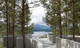
不同功能场所的特殊剖面要求整合设计成为丰富而连续变化的微地形。例如连接不同标高的露天剧场,穿梭在湿地中的抬升步道,攀岩和滑板乐园区域戏剧性的地形变化,不同特征的水岸线等。景观岛的地形设计尤其如此:在地段制高点9米处标志性的前海石主题广场,升起的地形中嵌入了一个小型的前海石纪念中心,为人们提供对地段历史的介绍;穿过展廊,到达运动中心:一座7米高的岩壁位于水面一侧,成为攀岩爱好者的乐土;滑板公园的人工地形创造出一系列惊险的瞬间;穿梭的跑道上下起伏……这一切构成了一个运动与自然共生的生活场景。

The integrated ecological infrastructure of this project emerges from three layers: the diversification of open spaces / activities, the complex multiplicity of connections, the pockets / landforms / platforms / wetlands biodiversity.
The site is wired by a continuous circulation circuit, linking in succession several nodes and generating, through punctual links, a spatial system of interdependent intensities: all the activities are located along the “Loop” – a seamless pedestrian and biking network. The island is situated inthe central intersection, connected with the mainland through three bridges. It’s the nodal attractor of the masterplan, the active-pulsating heart of the project through the articulation of the levels and the diversification of the programs, which are activated and deactivated by the tidal oscillations.
The topography is organized into three main levels: uplands, freshwater wetlands and tidal terraces. Given the existing grade, the southern channel is shallower than the northern one. Different platforms of tidal dynamics are planned to strategically embrace the topography and thecirculation, designed to provide unique spatial experiences throughout the various environmental conditions of the landscape. A diversity of plant communities are selected according to the humidity and salinity of different terraces. They range from mangrove, saltwater and (cleansing) freshwater wetlands to upland species.
The geometry of the central area is originated by the presence of the activities that have been integrated into its specific landform. At the islandcore the visitor could experience a brief introduction to the site history, passing through the main exhibition space; he could navigate and enjoythe diversity of material conditions, walking through multiple facilities: a rock-climbing wall overhanging on the central canal, a running track where to train on different slopes, a sunbathing area, a skate-park shaped by seamless and intricate hills…
The topographical reliefs of the central area are elaborated to revolve around the presence of the historical stone. The waterfront is the moment in which the complex articulation of the topography camouflages with the context. The program, the connections and the landforms disappear virtually to visually concretize on the central platform, the highest point of the masterplan where the stone is rendered as the main protagonist of the scene.

↑ 设计概念 | Design Concept多层整合景观基础设施系统:多样性的开放空间和活动场所,多路径连续一体的慢行网络,与地形紧密结合的生物多样性。Three layers are the generative elements of the integrated ecological infrastructure of the project: diversified open spaces and activities, pedestrian networks and bio-diversity.

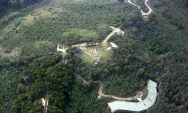
↑ 总平面图 | Masterplan方案与其周边环境无缝的连接起来,形成连续一体的慢行网络和景观基础设施。净水湿地与公园绿地与红树林融为整合的总体,将场地巧妙的布局和划分成功能多样,形式各异的活动空间。The project is carefully wired into the overall circulation and ecologic networks of its context. Lawns, freshwater wetlands and mangroves provide various landscape elements to a number of diverse public spaces.

↑ 功能布局与流线设计 | Program Layout and Site Circulation连续的慢行系统将多样的公共活动空间和景观节点串联起来。景观岛位于多个步道圈的中央交叉点,作为一个视觉标志物和公共活动中心,并与两侧的城市以三条步道和一个浮桥连接起来。All the activities are linked through the “Loop” – a seamless pedestrian and biking network. The island is situated in the central intersection, connected with the mainland through three bridges.


↑ 地形设计 | Topography延续总体规划中的“三台阶”形式,利用一系列的台地连接城市与水面标高,并根据他们与海平面的高差关系分为高地,淡水湿地和海水湿地。满足防潮防洪排涝的同时营造丰富的空间体验。The topography is organized into three main levels: upland, freshwater wetlands and tidal terraces. In order to minimize the dredging, the southern channel is shallower than the northern one.

↑ 剖面设计 | Sections不同功能场所的特殊剖面要求整合设计成为丰富而连续变化的微地形。例如连接不同标高的露天剧场,穿梭在湿地中的抬升步道,攀岩和滑板乐园区域戏剧性的地形变化,不同特征的水岸线等。Specific topographic conditions are integrated into various and well connected landforms. Eg: amphitheater / rock climbing / skate-park…

↑ 不同水位情形的动态景观 | Tidal Dynamics方案的地形和流线设计充分考虑了对海潮水位一日中时间性、季节性变化的包容,并利用自然的动态性在不同天气、潮汐状况下为使用者提供丰富而多样的景观空间体验和与自然互动的机会。Different levels of tidal dynamics are allowed and embraced in the overall topography and circulation design, providing unique spatial experiencesthroughout the landscape under various environmental conditions.

↑ 植物设计 | Planting Design结合场地现状特性,从盐度和干湿变化的角度将植物群落分为红树林滨海湿地、海水及(净化)淡水湿地及陆地植物。结合高低起伏的地形变化,为游园、戏水、晨练等活动创造丰富适宜的场所。A diversity of plant communities are selected according to the humidity and salinity of the different terraces. They range from mangrove, saltwater and (cleansing) freshwater wetlands to upland species.

↑ 景观岛节点 | The Island 前海石景观岛处于整个慢行网络的核心区域,位于多个慢行圈的中央交叉点,也因此是休闲活动最为集中和多样的区域。The island is the nodal attractor of the masterplan, the different programs are activated and deactivated by the tidal oscillations.

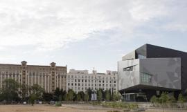
↑ 整体鸟瞰 | Aerial View景观岛的设计为前海石提供了一个处于地段制高点的精彩展示平台,并共同成为个性鲜明的视觉标志物。The island is the plate that highlights the importance of the stone-monument, the highest point of the masterplan where the stone is rendered as themain protagonist of the scene.

↑ 整体鸟瞰 | Aerial View从前海湾海岸线望去,整个方案与其周边的地形和城市景观协调的连接在一起。The waterfront is the moment in which the topography suddenly camouflages with the context. The program, the connections, the landforms virtually disappear to attract the visitors towards the central terrace.
MORE: reMIX
via:gooood.hk |
|