如何运用无人机来制作3D环境模型
How to Use a Drone to Create a Detailed 3D Context Model
由专筑网李韧,吴静雅编译
在Lumion等3D可视化软件的应用中,OpenStreetMap(OSM)和卫星地图等功能可以让你更加了解设计场地背景,通过这些功能,你可以快速地了解到与项目场地相关的城市与乡村环境,但是只依靠它们却远远不够。举例来说,OSM只能显示大致粗略的建筑形态以及单色的渲染体量,而卫星地图只能给出平面参考,不具有时效性,而且对于客户可视化来说,分辨率太低。
While working in 3D-visualization software such as Lumion, features such as OpenStreetMap (OSM) and satellite ground planes can provide some context for your design. They are suitable options for quickly building urban or rural environments relevant to your project’s location, but they’re also limited. For instance, OSM only provides rough building shapes, rendered white, and the satellite maps are flat, often outdated, and the resolution is too low for client visualization.
这些让我不禁开始思考,必须有更好的方法来全面了解背景环境,而不是单单通过失真的画面。我从谷歌地球和谷歌地球SDKs着手研究,但是它们的数据范围都无法超过谷歌地图或谷歌地球,比如用于建筑可视化。
还有一种解决方法便是通过无人机拍摄的一系列的=照片来构成周边环境的3D模型,这种技术有时候用于施工场地或项目监督,但尚未广泛用于目建筑设计和可视化。
为了测试它的可行性,我们运用无人机到3D工作流程完成几个真实的设计项目,根据经验,我们规划了一个简单的、为建筑师所用的工作流程。首先运用无人机和RealityCapture软件,现在可以捕捉到300X300米的画面范围,同时能够保证充足的3D纹理,然后结合Lumion可视化进行效果呈现。
甚至,你可以当天就完成这项任务。
This all got me thinking—there has to be a better way to improve fast context-building without having to sacrifice photorealism. I investigated several options, starting with Google Maps and Google Earth SDKs, but these services do not allow their data to be used outside the scope of Google Maps and Google Earth, such as for architectural visualization.
One solution is to create a 3D model of the environment using a series of photographs taken by a drone. This technique is sometimes used at construction sites to monitor progress, but it is not yet widely used for architecture design and visualization.
To test its viability, we used a drone-to-3D workflow for several real-life design projects. From our experiences, we derived a workflow simple enough to be used by architects (and not only 3D specialists). Using a modern drone and the software RealityCapture, it is now possible to capture an area of 300 x 300 meters and create a textured 3D model of sufficient quality for presenting a realistic background for your Lumion visualization.
Oh, and you can do all of this in one day.
工作流概况
这只是大致的工作流程版本。
步骤1:首先,你还是得有一台无人机
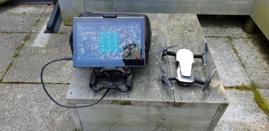
近年来,无人机的价格愈发便宜,体积也越来越小,但是功能却愈发强大,在工作流之中,我运用的无人机型是DJI Mavic Air,其售价为800美元,重量不到一斤,一次充电可以飞行20分钟。DJI Mavic Air可以覆盖10公里的距离,制作4K视频和4000 x 3000的高分辨率图像,这足以满足我们创建3D环境作为建筑设计或可视化背景的目的。
另外,我还建议你多准备一块电池,如果需要的话,还可以准备一台10英寸的安卓平板电脑。
Workflow Summary
This summary is a condensed version. Click here for the full drone-to-3D workflow story (PDF).
Step 1: Buy a Drone
Drones are getting cheaper, smaller and increasingly powerful by the minute. For this workflow, I used the DJI Mavic Air. It costs $800, weighs less than half a kilogram and it can fly for 20 minutes on one battery. The DJI Mavic Air can also cover a distance of 10 kilometers and make 4K video and 4000 x 3000 images with good resolution. This is adequate for our purpose of creating 3D environments as a backdrop for architecture design or visualization.
Also, I’d recommend that you buy some extra drone batteries and, if needed, a 10-inch Android tablet.
步骤2:拍摄无人机画面
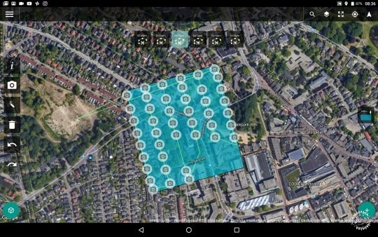
你可以运用平板电脑上的特殊应用程序,比如Drone Harmony软件来控制无人机,然后便是拍摄项目的场地图像。
通过Drone Harmony,你可以先在地图上勾勒出特定的区域,再计算无人机的飞行路径,自动捕获图像,并且每张照片与前一张照片的重叠率为60%,这是后期3D模型自动创建的需要。
在目标区域,无人机会进行五次同一飞行路径的运行,但是每次飞行都有着不同的摄像角度,例如无人机相机可以先朝下,然后再倾斜45度,每次飞行时间大约为7至15分钟,因此总时间大约为60分钟至90分钟。
Step 2: Capture Drone Images
Using a special app on your tablet for controlling a drone such as Drone Harmony, the second step is to capture images around the area of interest.
The Drone Harmony app lets you draw the area of interest on a map, and then it calculates the flight path of the drone, capturing images automatically with a 60% overlap from the previous shot. This overlap is needed for automatic 3D model construction.
Do five runs of the same flight path above the desired area, but make sure you assign a different camera angle for each flight. For instance, you can fly the first run with the camera pointed down and the other four runs with the camera tilted at 45 degrees. Each run takes 7 to 15 minutes, so the entire flying will take about 1 to 1.5 hours overall.
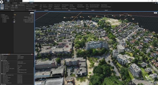
步骤3:将图像输入RealityCapture (RC)
虽然,通过其他不同的软件也可以将无人机图像合成3D模型,但我发现其实RealityCapture的功能最为强大。首先,RealityCapture能够自动对齐图像,然后合成3D模型,再添加肌理,并检测模型质量。这大概需要花费几分钟的手动操作,软件在后台处理过程中需要几个小时便能完成。
Step 3: Enter images into RealityCapture (RC)
While there are many different software programs for compiling drone images into a 3D model, I found RealityCapture to be the best option. RealityCapture automatically aligns all of the images and then creates a 3D model, adds textures, and inspects the model’s quality. This literally takes a few minutes of manual work, and a few hours at most of background processing by the RealityCapture software.
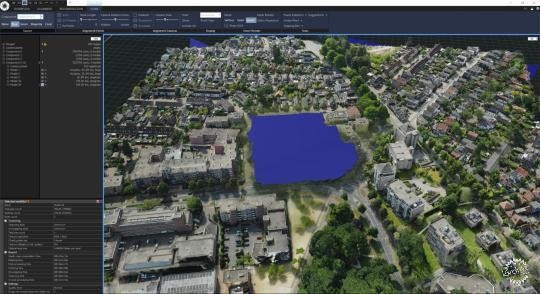
步骤4:删除缺乏细节的区域和不清晰的部分
如果你对模型质量很满意,那么下一步便是删除一些缺乏细节的区域和不需要的图像,从而将3D模型进行简化,根据模型的大小和复杂程度,大约需要3万至100万个组件。
然后添加肌理,并通过FBX格式最终输出,简化模型的过程大约为20分钟至1个小时。
Step 4: Cut out the less-detailed areas and unwanted objects
If the quality of the model is OK, the next step is to cut out the less-detailed areas and unwanted objects and then simplify the 3D model to a smaller model. Depending on the model’s size and complexity, this can be anything between 30 thousand and 1 million triangles.
Texture the model again and export it in an FBX format. Cutting and simplifying the model takes between 20 minutes and one hour.
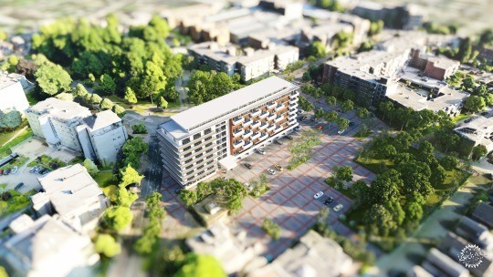
步骤5:将模型导入Lumion
将3D无人机模型导入Lumion之后,你可以自行添加一些树木、汽车、人物、家具等装饰。还可以从SU或诸如Revit、3ds Max、AutoCAD、Rhino等软件中导入设计方案,然后进行图像渲染和动画制作。
这个过程的时间大约为15分钟或几个小时。
如果你想要更加详细的指导说明和图像视频解析,可以查看完整版的无人机工作流文件。
Step 5: Import the model into Lumion
After importing the 3D drone model into Lumion, you can dress it up with trees, cars, people, furniture, etc. You can also import your design from SketchUp or your CAD/BIM program (Revit, 3ds Max, AutoCAD, Rhino, etc) on a separate layer, and make renders and animations.
This typically takes anywhere between 15 minutes and several hours.
If you want the full story, with detailed information and tons of great images and videos, check out the full Drone-to-3D workflow (PDF).
真实项目中的工作流测试
在几个实际项目中,我便使用了这个工作流,其中一个是海滩与沙地项目,我以其中现有的住宅为例。其余的两个项目恩别是当地建筑师完成的商业设计。接下来将简要描述这些项目。
Testing the Workflow on Real-Life Projects
I used this workflow for several projects. One was a test project of a beach and dune area featuring an existing Lumion example house. The remaining two were commercial design projects from local architects. These are briefly described in the next sections.
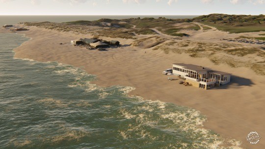
海滩与沙地项目
测试项目。这座现有的Lumion海滨住宅位于荷兰海牙附近的沙滩上,占地面积为500 x 500米。
Beach and Dune Area
Test project. Existing Lumion beach bungalow added to a 500 x 500-meter captured beach area near The Hague, The Netherlands. (Download this Lumion Project)
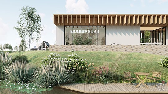
Nesselande 项目 / Studio Aaan
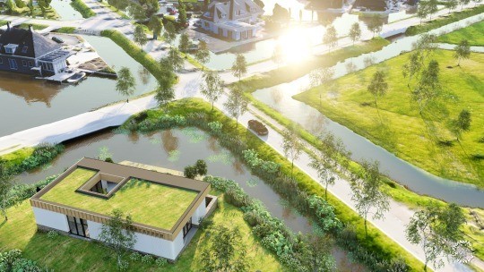
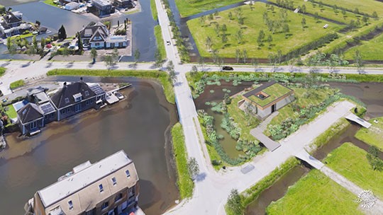
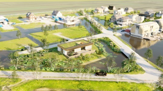
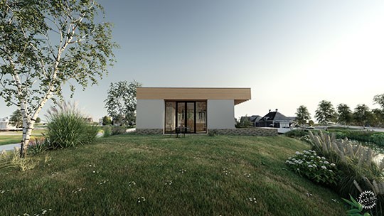
该项目位于荷兰鹿特丹附近的一个小岛上,这是座全新住宅小区的私人住宅。
Nesselande Project / Studio Aaan
Private house design on a small island in a new residential area near Rotterdam, The Netherlands.
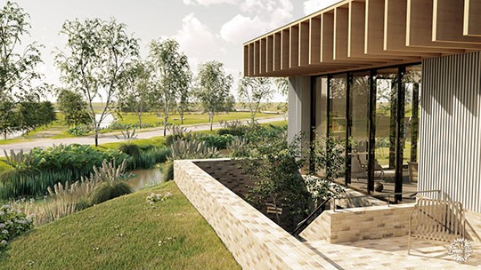
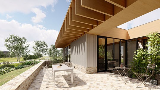
Studio Aaan的建筑师Hilbrand Wanders说:“只有建筑建成、使用者搬进来之后,人们才能更加精准地感受到建筑空间,例如树木的投影、外部的视线遮挡,亦或是窗口的定位等等。这些方面对于使用者来说有着很大的影响,在设计的早期,如果通过手工模型来推敲周边的环境,虽然很细致,但是耗时太多。因此如果通过3D模型,建筑师就可以在这个模拟环境中测试不同的设计思路,同时通过清晰的图像将设计理念向使用者表达出来。同时也以非常清晰和诱人的形式将这些设计传达给客户。“
From architect Hilbrand Wanders of Studio Aaan: "Only once a house is finished and the owners move in, one can precisely see how certain trees are creating shadows in the house, what objects in the surroundings are blocking views from a certain position, or how window openings are positioned relative to window openings of the surrounding buildings. These aspects are highly influential on the living qualities and are difficult and too time-consuming to model by hand completely early in the design process. It is very interesting for a designer to consider the correct 3D environment from the first moment on, to test the first design-ideas within a correct 3D surroundings, but also to communicate these to a client in a very clear and tempting format."
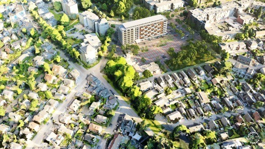
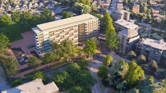
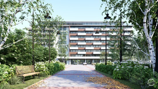
Westpoint Apeldoorn项目/ Paul Spaltman
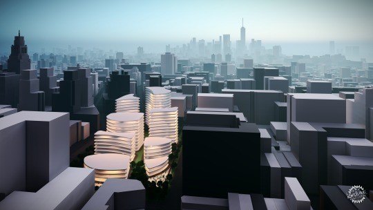
在荷兰阿珀尔多伦,一座现有的办公建筑被改造为有98间公寓的住宅楼,每间公寓都设置有阳台。
项目建筑师Paul Spaltman说:“我的设计方案和环境十分契合,这不仅仅针对设计过程,在与客户、政府人员、当地人民,亦或是其他相关者沟通时,这些表现都非常有价值。”
Westpoint Apeldoorn Project / Paul Spaltman
Refurbishment of an existing office building into 98 apartments, each with a balcony, in Apeldoorn, The Netherlands.
From architect Paul Spaltman: "The fact that my design was embedded so clearly in the environment is an added value, not only during the design, but also during presentations and discussions with the customers, governments, and local citizens or whoever is involved."

成本概况
这个表格总结了我所使用了硬件、软件,和其他的所需的组件,其中还包括它们的使用成本。
Cost Overview
The following table sums up the software and hardware components I used. Other components may be needed, with additional costs, as well:
通过无人机创建属于你自己的3D环境
我的经验告诉我,通过无人机进行3D环境模型的创建对于建筑设计可视化来说非常简单,并且有很高的可行性。
这项投资就时间而金钱来说都非常低,同时也不需要过多的专业技能学习。但是由此而得出的成果在设计过程和商务沟通方面都非常客观。
图片:Courtesy of Lumion
Creating Your Own 3D Environments with Drones
My experiences have shown that creating 3D environment models from drone images is very straightforward and feasible for any architecture design visualization.
The investment in time and money is relatively low, and any architect can do it without extensive training and/or the need for a 3rd-party service provider. The resulting models have value both in the design process (Lumion LiveSync) and for communicating with clients and other interest parties, like the city council and local citizens (Lumion rendered images and animations).
|
|
